


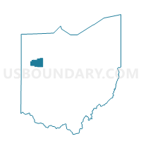
SHAWNEE TWP M Voting District, Allen County, Ohio
About
Outline

Summary
| Unique Area Identifier | 642571 |
| Name | SHAWNEE TWP M Voting District |
| County | Allen County |
| State | Ohio |
| Area (square miles) | 0.76 |
| Land Area (square miles) | 0.75 |
| Water Area (square miles) | 0.01 |
| % of Land Area | 98.58 |
| % of Water Area | 1.42 |
| Latitude of the Internal Point | 40.69004620 |
| Longtitude of the Internal Point | -84.19177660 |
Maps


Graphs
Select a template below for downloading or customizing gragh for SHAWNEE TWP M Voting District, Allen County, Ohio


Neighbors
Neighoring Voting District (by Name) Neighboring Voting District on the Map
- FT SHAW VILLAGE A Voting District, Allen County, OH
- SHAWNEE TWP E Voting District, Allen County, OH
- SHAWNEE TWP F Voting District, Allen County, OH
- SHAWNEE TWP J Voting District, Allen County, OH